

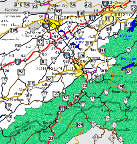
Interstate 26 runs 55 miles overall through eastern Tennessee alongside U.S. 23 from Sams Gap to U.S. 11W (W Stone Drive) at Kingsport. U.S. 23 extends the freeway north two miles from U.S. 11W to the Virginia state line. U.S. 19W overlaps with Interstate 26 north from Erwin through Johnson City to U.S. 11E.
Throughout eastern Tennessee, Interstate 26 and U.S. 23 are known as the James H. Quillen Parkway. Named in honor of the region's long-time U.S. House of Representatives member (1963 to 1997) who died on November 2, 2003 (shortly after the opening of Interstate 26),1 Interstate 26 is part of Appalachian Regional Development Corridor B, which connects Asheville, North Carolina, with Columbus, Ohio. While the corridor is upgraded to Interstate standards from Asheville to Kingsport, there are no short-term or mid-range plans to extend Interstate 26 north of Kingsport to Ohio.
Interstate 26 Tennessee Guides
- East - Kingsport to Johnson City
- East - Johnson City to Sams Gap
- West - Sams Gap to Johnson City
- West - Johnson City to Kingsport
Construction of Interstate 26 took place in phases: former Interstate 181 was completed and opened in 1985; the section from the Sams Gap and the North Carolina State Line north to Johnson City fully opened on July 6, 1995; and the section from Mars Hill, North Carolina, to Sams Gap opened on August 5, 2003. With all these segments complete, Interstate 26 was extended north from Asheville to the cloverleaf interchange with I-81.
I-26 overtook the southern half of Interstate 181 between U.S. 321 and I-81. The American Association of State Highway and Transportation Officials (AASHTO) approved a second extension of Interstate 26 northward over the remaining nine miles of I-181 on August 5, 2005. This extension was sought by the city of Kingsport. Turned down in June 2003, a previous proposal outlined renumbering I-181 as Interstate 126.
Remaining references of Interstate 181 were replaced in eastern Tennessee by March 2007. The sign changes accompanied the renumbering of all exits to reference the western end of Interstate 26 at Kingsport. Milepost zero within the exchange joining I-26/U.S. 23 with U.S. 11W in Kingsport.
When Interstate 26 replaced I-181, exit numbers were renumbered to increase from north to south:
| I-26 Exit Number | U.S. 23 Exit Number | Intersecting Road |
|---|---|---|
| 1 | 55 | U.S. 11W (Stone Drive) |
| 3 | 52 | Meadow View Parkway |
| 4A 4 |
51A | SR 93 South |
| 4B | 51B | SR 93 North (Wilcox Dr) |
| 6 | 49 | SR 347 (Rock Spring Road) |
| 8B | 46A | Interstate 81 North Bristol |
| 8A | 46B | Interstate 81 South Knoxville |
| 10 | 45 | Eastern Star Road |
| 13 | 42 | SR 75 Gray (Bobby Hicks Highway) |
| 17 | 38 | SR 354 Boones Creek |
| 19 | 36 | SR 381 (State of Franklin Rd ) |
| 20A 20B |
35A 35B |
U.S. 11E & 19W (North Roan Street) |
| 22 | 33 | SR 400 (Unaka / Watauga Avenues) |
| 23 | 32 | SR 91 (Market Street) |
| 24 | 31 | U.S. 321 Elizabethton |
| 27 | 28 | SR 359 (N Okalona Road) |
| 32 | 23 | SR 173 (Unicoi Road) |
| 34 | 21 | Tinker Road |
| 36 | 19 | Main Street Erwin |
| 37 | 18 | SR 81 / SR 107 Erwin-Jonesborough |
| 40 | 15 | Jackson-Love Highway |
| 43 | 12 | U.S. 19W / SR 352 (Temple Hill Road) |
| 46 | 9 | Clear Branch Road |
| 50 | 5 | Flag Pond Road |
 scenes scenes |
 | Boones Creek Road (SR 354) east at the entrance ramp to I-26/U.S. 23 north at Exit 17. Rather than replacing the I-181 shield initially, TDOT added an I-26 shield. Several Interstate 181 shields south of I-81 remained posted through late August 2003. 08/23/03 |
 | Boones Creek Road west at the I-26/U.S. 23 southbound on-ramp. The original I-181 shield was replaced with an I-26 shield. Since Interstate 181 was signed north-south, an East placard was added for then newly designated I-26. 08/23/03 |
      | A welcome center and rest area lie just off I-26/U.S. 23 at Exit 46 for Clear Branch Road. 10/25/15 |
http://www.jcmpo.org/i26.htm
Photo Credits:
- 08/23/03 by AARoads and Justin Cozart. 10/25/15 by AARoads.
Connect with:
Interstate 81
U.S. 321
Page Updated 08-09-2021.